On This Date In Twin Cities History - July 24, 1786
On this date in 1786, Joseph Nicolas Nicollet was born in Cluses, Savoy, France. Nicollet was a French geographer, astronomer, and mathematician known for mapping the Upper Mississippi River basin during the 1830s.
Before emigrating to the United States, Nicollet was a professor of mathematics at Collège Louis-le-Grand, and a professor and astronomer at the Paris Observatory. Nicollet left for the United States in 1832 after being financially ruined by the 1830 July Revolution. Upon arriving, he offered his services to the U. S. government in the mapping of the West.
Nicollet’s first expedition took place in 1836–37 and was privately funded. He departed Fort Snelling by canoe on July 29, 1836, accompanied by Chagobay, an Ojibwe chief, his nine-year-old son, and a half-French guide named Brunia. Nicollet explored the Mississippi to its source at Lake Itasca and the nearby Mississippi tributary, the St. Croix River.
Nicolet’s second expedition was was commissioned by the War Department’s new Corps of Topographical Engineers. The effort began on June 18, 1838 departing from Traverse des Sioux. His party included of John C. Frémont, who was appointed by the War Department to assist on the expedition in lieu of a military escort, Joseph Renville Jr., and Joseph LaFromboise, an agent for the American Fur Company. On July 4, 1838 the expedition arrived at Pipestone Quarry, where the party members carved their initials on a rock. From there, the party proceeded along the Minnesota and Blue Earth Rivers toward Spirit Lake, Iowa.
For his third and final expedition in 1839, Nicollet retained the services of Louison Freniere as his guide. Along with Fremont, Nicollet was also joined for part of his journey by the Jesuit Missionary Pierre-Jean De Smet. This journey was also government funded and took Nicollet northwest from Iowa along the Missouri River toward Fort Pierre, South Dakota. A second leg of this trip brought the party to Devil’s Lake, North Dakota. From there, Nicollet travelled back across the Coteau des Prairies to Fort Snelling.
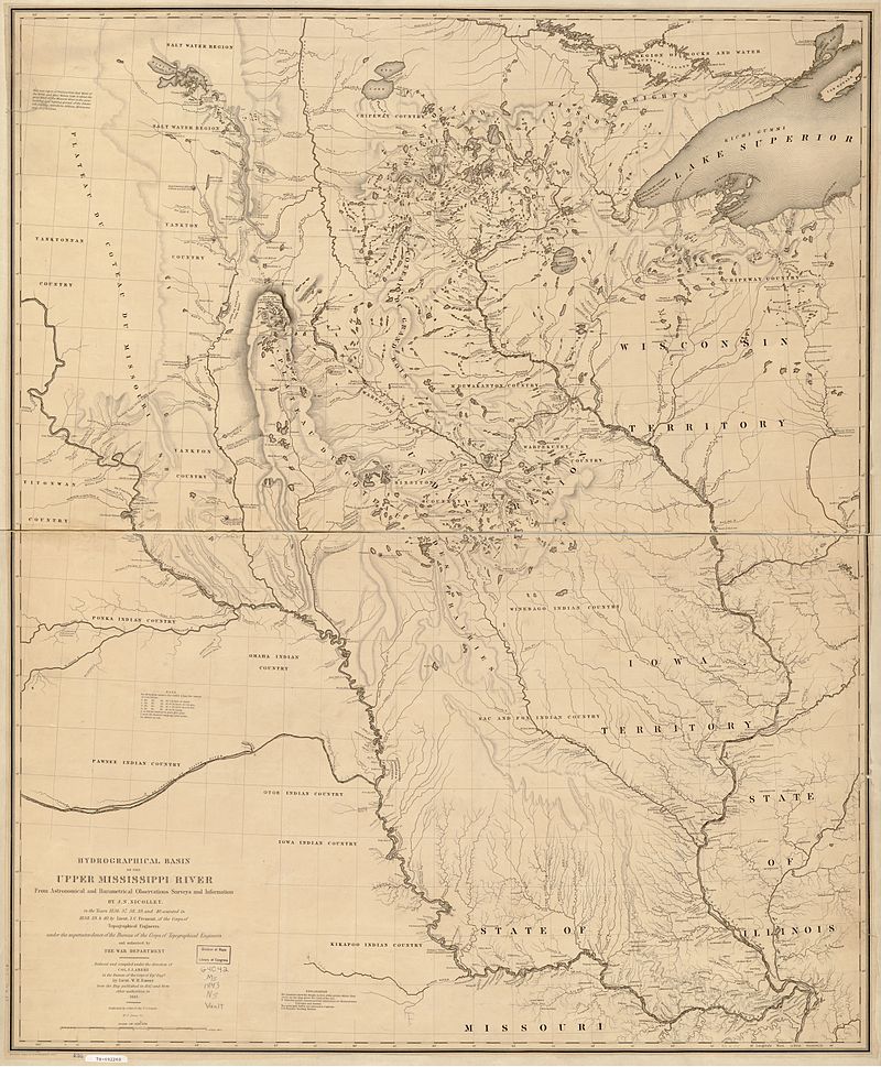
Nicollet returned to Washington, D.C. in September 1839 where he worked on organizing the information he collected on his journeys into the report to the Senate. He helped compile a mammoth map of the Midwest, the first accurate map of this part of the country.
Nicollet had plans to return to Minnesota to continue his work, but due to his failing health as a result of intestinal cancer. he died in Washington on September 11, 1843 and was buried at the Congressional Cemetery.
Nicollet’s maps were among the most accurate of the time, correcting errors made by Zebulon Pike. He stressed to map publishers the importance of elevation marks , or hachuring, on published maps. His maps would provide the basis for all subsequent maps of the American interior and were the only maps to use regional Native American place names at the time.
Today and number of place names in Minnesota are named for the explorer including Nicollet Avenue and the Nicollet Mall in Minneapolis.